
Made In America
Weather Closure Notice: Due to current weather conditions and for the safety of our staff, WISPR Systems offices are closed today and until further notice.
Made In America
In the world of drones, precision isn’t just a perk—it’s a necessity. Whether you’re surveying a construction site, measuring stockpile volumes, or inspecting critical infrastructure, a few feet of GPS error can mean costly rework and lost time. That’s why WISPR Systems integrates RTK (Real-Time Kinematic) positioning into the SkyScout—taking your data accuracy from a ballpark estimate to pinpoint precision.
If you’re new to drones or just exploring what RTK can do, this guide will walk you through exactly how the RTK workflow works with the WISPR SkyScout, and why it’s changing the game for mapping, surveying, construction, agriculture, and beyond.
Let’s break it down. RTK stands for Real-Time Kinematic positioning. It’s a GPS correction technology that uses a base station or a network to fine-tune the signals your drone receives from satellites.
Standard GPS alone gets you within about 1–3 meters of the actual location. RTK narrows that margin of error to about 2–5 centimeters—in real time. That level of accuracy unlocks reliable maps, precise measurements, and trustworthy models or overlays without the time-consuming hassle of placing dozens of ground control points (GCPs).
Ever wonder what’s actually happening behind the scenes during an RTK-enabled flight? This quick animation shows how the WISPR SkyScout, GPS satellites, and a GNSS base station work together in real time to precisely geo-tag every image—no manual tagging or ground control points required.
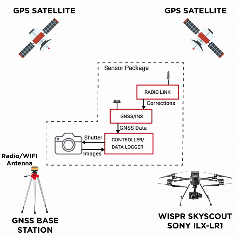
From the GNSS base station to your drone’s onboard data logger, each component plays a role in ensuring accuracy with every shot. It’s a seamless loop of corrections, positioning data, and image capture—resulting in survey-grade results straight out of the sky.
To get RTK corrections, you’ll need either a physical base station or access to a correction network. Many users place a GNSS receiver (base station) on a known survey point on-site. Others use a network correction service (called NTRIP) that feeds corrections to the drone via a cellular connection.
WISPR SkyScout’s system makes this straightforward. During your initial setup or training, our team will help configure your RTK settings. Most of the time, all you’ll do is power up, connect to your base or enter your NTRIP login on the controller or ground station—and you’re good to go.
Once your RTK link is live, it’s time to plan your flight path. Hop in WISPR Ground Control to utilize the easiest flight planning software on the market.
Choose your geotagging preferences, set your grid, altitude, overlap, and other mission parameters. Most importantly, double-check that the RTK status icon is green. This confirms your drone is locked onto those centimeter-level corrections for every shot it takes.
With everything connected and your mission set, you’re ready for takeoff. From here, the magic happens behind the scenes.
Your RTK-enabled WISPR SkyScout continuously communicates with the base station or network as it flies. Every photo, waypoint, or inspection point it captures is tagged with high-precision coordinates—no need to manually mark or measure spots on the ground.
For many projects, this means you can skip setting up multiple ground control points altogether. If you still want maximum accuracy or need to meet strict survey standards, adding a few GCPs for validation can tighten results even more.
With the WISPR SkyScout, every image is automatically geotagged during flight—directly on the SD card—so you can begin processing the moment you land. There’s no need for file conversions or extra post-processing steps. Just drop your images into your software of choice, like Pix4D, gNext Labs, Carlson Point Cloud, or Trimble Business Center (TBC).
The built-in RTK system provides the high level of accuracy needed for most mapping and modeling projects—offering speed, precision, and simplicity in one streamlined workflow. For teams that prefer the added control and reliability of a PPK (Post-Processed Kinematic) workflow, WISPR also offers easy-to-use cloud-based tools for seamless integration.
Note: The WISPR SkyScout is PPK-capable out of the box — no additional hardware is required. If your workflow demands higher positional accuracy than RTK provides, you can export your flight logs and process them using our cloud-based PPK software (available via subscription).
Not every job site is created equal. RTK shines brightest when the margin for error must be razor-thin, and time is money.
Here are a few real-world applications where WISPR users see the biggest ROI:
For first-time drone pilots, RTK might sound intimidating at first—but here’s the good news: with WISPR SkyScout, it’s plug-and-play. Our drones, software, and support make high-accuracy workflows accessible, even if you’re not a seasoned surveyor.
RTK drastically cuts down on manual setup, reduces the need for physical markers, and speeds up the entire process. Large or hard-to-reach sites become more manageable because your drone does the legwork, not your crew. And in the end, you deliver maps and reports your clients can trust—without second-guessing the data.
Curious what a real RTK mission looks like? Check out this quick video walkthrough to see how easy it is to unlock next-level accuracy with the WISPR SkyScout in the field.
With RTK onboard, your WISPR SkyScout doesn’t just fly—it delivers data you can rely on, job after job. Whether you’re an experienced surveyor or just starting out, adding RTK to your workflow means faster projects, tighter accuracy, and fewer headaches.
Need help setting up your RTK system? Our team is ready to get you dialed in and flying with confidence. Contact us today to learn more or schedule a demo.
With world-class training and support, owning one of our WISPR Systems American-made drones means years of productive and well-supported flying.
