
Made In America
Weather Closure Notice: Due to current weather conditions and for the safety of our staff, WISPR Systems offices are closed today and until further notice.
Made In America
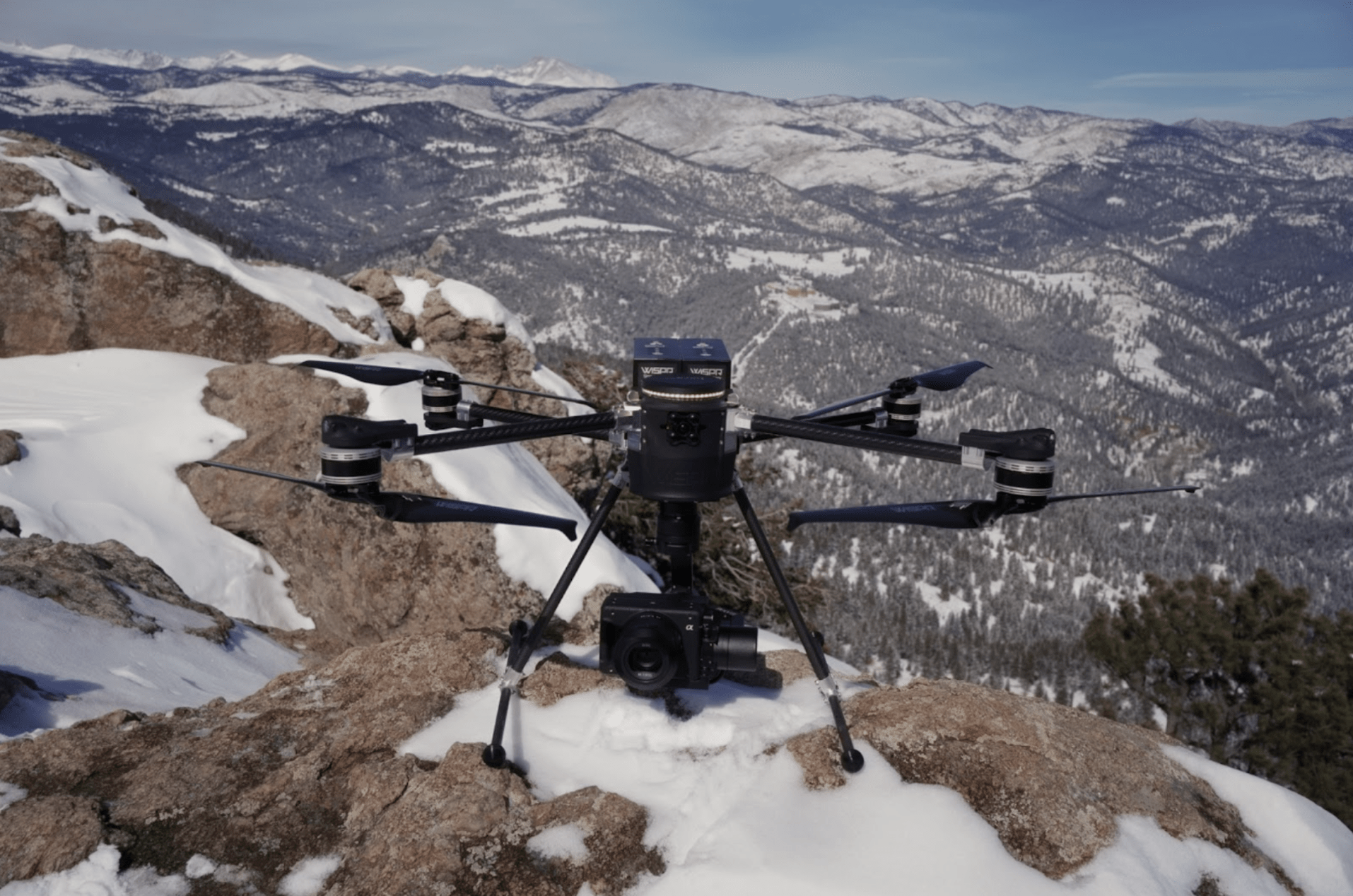
WISPR SkyScout with Sony ILX-LR1
Mapping & Inspection
The world of aerial data collection is evolving rapidly, and professionals across industries are seeking reliable, high-performance solutions to enhance efficiency and accuracy. WISPR Systems’ SkyScout stands out as a versatile, rugged and highly capable drone designed for photogrammetry, LiDAR, mapping, surveying and inspection applications. Whether you’re capturing high-resolution images for 3D modeling, conducting detailed land surveys or inspecting critical infrastructure, SkyScout is built to deliver unmatched precision and performance.
Photogrammetry is the backbone of many mapping and modeling applications, requiring drones that can capture high-resolution, georeferenced images with exceptional clarity. SkyScout is equipped with:
With SkyScout, surveyors and engineers can generate detailed 3D models, orthomosaic maps and digital elevation models (DEMs) with ease. Its ability to collect accurate aerial imagery with minimal overlap reduces processing time while improving data quality and resolution.
LiDAR (Light Detection and Ranging) has revolutionized topographical mapping, forestry analysis and infrastructure planning. SkyScout is engineered to seamlessly integrate with LiDAR sensors, allowing professionals to:
SkyScout’s robust flight stability and payload capacity ensure that LiDAR sensors operate smoothly and efficiently, even in challenging environments. The result? Highly detailed, actionable data for industries that demand the highest level of accuracy.
Accurate mapping and surveying require drones with long flight times, high payload capacity and advanced navigation systems. SkyScout meets these demands by offering:
From construction site planning and land development to agricultural analysis and environmental monitoring, SkyScout provides professionals with the tools to collect, process and analyze geospatial data more efficiently than ever before.
Infrastructure inspections demand close-range, high-detail imaging, often in environments that are difficult or dangerous for human access. SkyScout enhances safety and efficiency by enabling:
By eliminating the need for manual inspections in hazardous locations, SkyScout minimizes downtime, reduces costs and improves overall safety for industries such as utilities, energy and telecommunications.
Why SkyScout? The WISPR Advantage
SkyScout isn’t just another drone—it’s a high-performance UAV designed to meet the evolving needs of industry professionals. With:
✔ Customizable payload options for specialized applications
✔ Extended flight times to maximize operational efficiency
✔ Rugged, field-tested durability for challenging conditions
✔ Seamless software integration for easy data processing
SkyScout provides an all-in-one solution for photogrammetry, LiDAR, mapping and inspections, ensuring unmatched reliability and precision in the field.
Take Your Drone Operations to the Next Level
Ready to enhance your aerial data collection and analysis? Whether you’re a surveyor, engineer, infrastructure inspector or GIS professional, SkyScout is the ideal tool to streamline workflows, improve accuracy and maximize efficiency.
Contact WISPR Systems today to learn more about how SkyScout can transform your operations!
With world-class training and support, owning one of our WISPR Systems American-made drones means years of productive and well-supported flying.
